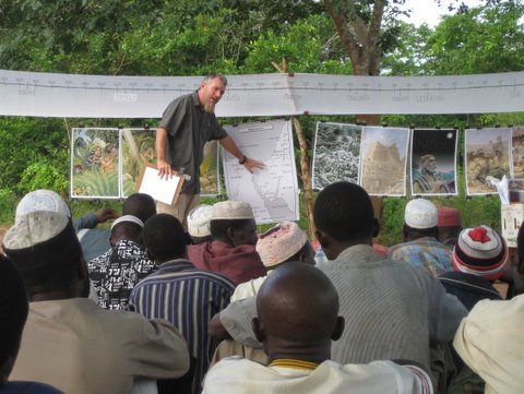
 One of the ministry tools we use a lot is a map. The mission has a nice program that we can use to produce maps in the local language. We took the maps and print them in poster sizes and laminated them. We have several maps that we use in this way. We have seen their value in using them in translation as well as in curriculum development but they are really useful in the public teaching. For people that have a very fuzzy concept of what the wider world is like the maps really help to communicate that what we are talking about really did take place in a real place. Some of the events (like the Joseph story and the Exodus that we are teaching about this week) took place on this very same continent that we are on right now. It is nice to be able to compare distances during the teaching. When Abraham left Ur and went to Haran it was similar to a local walking on foot from where we are to the capital city way off in the south. Most people have never been anywhere near it but they know it is a long way away and takes 3 days by bus. Now imagine taking that walk while herding a big flock of sheep and other animals. It really helps communicate the enormity of the move that Abraham undertook without knowing where God was taking him. Sometimes the distances are closer. When Joseph went off to look for his older brothers we can say it was the same distance as a local walking from village A to village B. This really helps the audience get a better feel for what was involved in the stories.